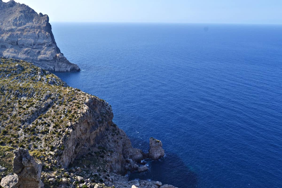
Serra de Tramuntana (UNESCO World Heritage)
Serra de Tramuntana
Balearic Islands (Mallorca / Sóller / Valldemossa / Pollença / Deià) · Spain
Photo: Lolagt · CC BY-SA 4.0 · Wikimedia Commons
Mallorca's limestone backbone (Puig Major 1.445 m), deep gorges like Torrent de Pareis, and the world's only island redoubt for black vultures and the Majorcan midwife toad (Alytes muletensis).
Picture a wall of limestone culminating in the highest peak of the Balearics, Puig Major at 1.436 m. That is the Serra de Tramuntana: a mountain territory spanning 62.403 ha of land and 1.123 ha of sea, spread across 20 municipalities. It was designated a Natural Site on 16 March 2007, and on 27 June 2011 UNESCO declared it a World Heritage Site in the cultural landscape category.
What makes it unique
A mountain range where millennia of farming in a water-scarce environment carved terraces, aqueducts, and dry-stone structures directly into a limestone massif.
The place
Nature
The landscape
Rainfall is the master sculptor. The Serra de Tramuntana catches significantly more precipitation than the rest of Mallorca, up to 1507 mm annually compared to less than 400 mm elsewhere on the island, and snowfall is regular in winter. This water dissolves predominantly limestone bedrock, sculpting a fluted karst landscape of lapiaz, chasms, and caverns: Cova de sa Campana, at -358 m, is the deepest cave in Mallorca, and the range also holds the island's deepest subterranean lake. In the Torrent de Pareis, vertical cliffs soar 300 m high.
Vegetation mirrors the rainfall pattern: the range shelters Mallorca's finest holm oak forests. The most valuable botanical habitats thrive in the most inaccessible cliffs, concentrating endemics and threatened flora: 25 endemic plant species and 7 taxa found exclusively on Mallorca. Isolated specimens clinging to crags represent living relicts of colder climatic eras, with specialized communities inhabiting shady gullies, karst springs, deep fissures, and dense oak groves.
The sea is equally vital. The marine perimeter preserves extensive Posidonia oceanica meadows, maërl beds, and rich coralligenous reefs.
Wildlife and seasons
Begin on the cliffs. Here resides the world's only island breeding population of the cinereous vulture, and the osprey stands out with its plunging fishing technique. Eleonora's falcon is a unique raptor that migrates to breed in the Balearic archipelago in late summer and autumn, unlike almost all other European birds of prey. The red kite nests in pine canopies, and having once hovered near regional extinction, it is now commonly seen soaring overhead.
In the most secluded torrent gorges lives the Majorcan midwife toad, an endemic amphibian today severely threatened by the introduced viperine water snake; it was initially described as a fossil before living specimens were discovered years later. In the south, among scrub and dry farmland, lives the Moorish tortoise, classified as vulnerable and threatened by habitat degradation and illegal collection. Deep caves provide winter roosts and nursery colonies for cave-dwelling bats.
Introduced mammals include common genet, European pine marten, least weasel, and feral raccoon. The best months to visit are spring and autumn.
Species
With a page in the atlas
Being mentioned in a source doesn't guarantee sightings: check with the people who manage the area.
Memory and protection
History and conservation
The Island Council maintains a management plan to coordinate conservation actions for the World Heritage site. UNESCO emphasizes that millennia of farming in a resource-scarce environment transformed the landscape, leaving agricultural terraces, water mills, dry-stone structures, and traditional estates.
Nearly 95 % of the protected area is privately owned, with the remainder consisting of public estates. The protected site also encompasses the natural monuments of Ses Fonts Ufanes and the gorges of Torrent de Pareis, Gorg Blau, and Lluc, alongside areas of the European Natura 2000 network.
Before you set off
Visiting
How to visit
The premier access corridor is the Ma-10 mountain highway, winding through the range from Andratx in the south to Pollença in the north, connecting all 20 municipalities. Begin at Lluc, where the Ca s'Amitger interpretation center sits just before the Sanctuary car park on the left, open daily from 9 to 16 h except Christmas, New Year's Day, and Epiphany. It features an informative permanent exhibition on the natural and cultural values of the massif, with self-guided trail pamphlets.
The backbone hiking route is the GR221 Dry Stone Route, with 183,3 kilometers open and waymarked, 102,3 of which form the continuous main trail. Coll de ses Cases de sa Neu is the trail's highest pass, sitting just above twelve hundred meters, and can be walked almost year-round thanks to Mallorca's mild climate. Highlights include the section from Cúber to Biniaraix past the Cúber reservoir at 750 m surrounded by the highest peaks, and the Barranc de Biniaraix, a stepped dry-stone gorge designated an Asset of Cultural Interest.
Accessible Joëlette all-terrain wheelchair routes exist at Ses Fonts Ufanes, Planícia, and Sa Volta des General; equipment loan is free of charge.
Before you go
Many estates graze livestock: always leave gates as you find them and keep dogs on a leash. Drone flights and commercial filming require prior authorization from the protected area, and crossing private land requires permission from landowners. For hiking, wear suitable clothing and footwear, carry plenty of water and sun protection; in an emergency, call 112. Avoid loud noises that disturb wildlife, pack out all litter, and never use shortcuts that worsen erosion.
The wildfire risk season runs from 1 May to 15 October. Visitor numbers are high in Valldemossa, Sóller, Formentor, and Sa Calobra in summer.
Check access, rules and visiting conditions in the official information from the managing body before you set off.
Location
Where it is and how far it reaches
Boundary of Serra de Tramuntana · © EEA, CDDA (CC-BY) The coordinate is estimated; it isn't a verified access point.
Transparency
Sources
The research data with its sources, and the official links for this place, are in the Spanish version of this page. See the Spanish version
Around it
About thirteen kilometers away lies the S'Albufera de Mallorca Natural Park.
Farther away, the Serra da Malcata Nature Reserve in Portugal shares the common genet and black vulture with the range.
What else to explore nearby
Approximate straight-line distance between the edges of each area. It doesn't indicate access, routes or driving times.
- S'Albufera de Mallorca Natural Park
Balearic Islands (Mallorca / Muro / Alcúdia / Sa Pobla)
About 7 km away
The largest wetland in the Balearic Islands (1,700 ha), a lagoon of brackish reedbeds with outstanding bird observation hides in the Bay of Alcúdia.
JFMAMJJASONDMarch – May · September – November · Crowding low
If you like this place, elsewhere in Europe
Distant places with uncommon wildlife and habitats in common. The most widespread species don't count. Sharing species doesn't imply a corridor or guaranteed presence.
- Retezat National Park
Hunedoara County (Hațeg)
In common: Mustela nivalis · European pine marten — high mountain, old-growth forest
The realm of the granitic and glacial Retezat, with over 80 crystal tarns and the Gemenele scientific reserve.
JFMAMJJASONDJune – October · Crowding low
- Măcin Mountains National Park
Tulcea County (Greci / Măcin)
In common: Moorish tortoise · European pine marten — high mountain, old-growth forest
Europe's oldest mountains (over 300 million years old), with Pontic-Sarmatic steppe, sub-Mediterranean forests, and raptor migration flyways.
JFMAMJJASONDApril – June · September – October · Crowding very low
- Jizera Mountains Beechwoods
Liberec Region (Jizera Mountains)
In common: Red kite · European pine marten — high mountain
Spectacular mountain slope clothed in ancient beechwoods with granite outcrops, inscribed by UNESCO.
JFMAMJJASONDMay – October · Crowding low
Entry #635 of the original atlas.