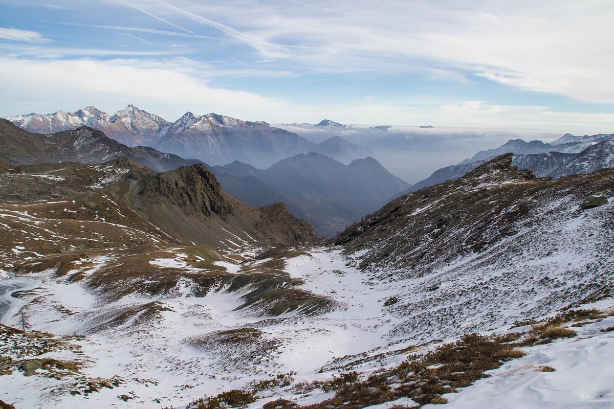
Mont Avic Natural Park
Parco Naturale Mont Avic
Aosta Valley (Champdepraz / Champorcher) · Italy
Photo: Marco Soggetto · CC BY-SA 4.0 · Wikimedia Commons
The first Natural Park in the Aosta Valley, featuring the region's largest continuous stand of mountain pine (Pinus uncinata) and over 30 glacial cirque tarns.
Mont Avic lies off the beaten tourist track of the Aosta Valley, and that seclusion defines its character. Tucked between the Champdepraz ravine and the Champorcher valley, it preserves the largest mountain pine forest in the Italian Alps: over 1.100 hectares of a hardy conifer that thrives in peat bogs, rocky fissures, and nutrient-poor soils where almost nothing else can grow. Gran Paradiso lies right next door, yet this park—the first regional natural park created in the Aosta Valley—remains an unspoiled haven where alpine ibex, chamois, and marmots can be observed in complete tranquility.
What makes it unique
Forests that rely on the root systems of a single species: at least one hundred fungi species live in mycorrhizal symbiosis with the roots of Mont Avic's mountain pine.
The place
Nature
The landscape
Mont Avic is a world sculpted from greenstone. The park's bedrock consists of ophiolites, fragments of ancient oceanic crust swept into the Alpine orogeny when Africa collided with Europe. These serpentinites weather into shallow, nutrient-starved soils laden with toxic heavy metals such as nickel, chromium, and cobalt. Consequently, only a specialized flora can survive, complemented by more than one hundred species of saxicolous lichens.
Quaternary glaciers completed the topography: polished rock slabs, striations, and numerous glacial cirques now cradle high-mountain lakes, particularly across the southern sector. This glaciation produced abundant wetlands and peat bogs—rarities across the valleys of the western Italian Alps, yet so widespread here that they constitute the park's most significant biotopes.
Three jagged peaks encircle the park: Mont Avic (3.003 m), Mont Iverta (2.936 m), and Mont Glacier (3.186 m) demarcate the Champdepraz gorge from the Champorcher valley. Below them, unbroken forests stretch past 2.000 m. In the Chalamy valley, mountain pine largely replaces larch and Norway spruce, accompanied by montane beechwoods absent from most of the upper Aosta Valley. Where pines grow on acidic peat or in rock crevices, their stunted growth creates genuine natural bonsai trees.
Wildlife and seasons
The Dondena basin offers prime vantage points to observe prominent mammals such as the alpine marmot, alpine ibex, and chamois across wide alpine meadows punctuated by rocky outcrops. Mountain hares also inhabit these heights, while roe deer, red squirrels, and garden dormice occupy the Chalamy woods.
Avian life is exceptionally rich: over 120 species have been recorded, with more than 90 breeding locally. Three pairs of golden eagles maintain territories spanning the park, the right flank of the Dora Baltea, and the head of the Champorcher valley. Rock ptarmigans, glacial relicts of the alpine tundra, dwell above 2.100-2.200 m. The black grouse is monitored each spring during courtship displays, digging snow caves during winter to roost. In ancient woodlands, the black woodpecker occurs at a density of roughly one pair per 300 hectares.
Invertebrate diversity proves remarkable: over 1.100 butterfly and moth species, accounting for 70 % of all macrolepidoptera recorded across the Aosta Valley, including four microlepidoptera species new to science. In summer, peat bogs are blanketed with white cotton-grass tassels among mosses, thirteen sphagnum species, and carnivorous round-leaved sundews.
Species
With a page in the atlas
Being mentioned in a source doesn't guarantee sightings: check with the people who manage the area.
Memory and protection
History and conservation
The natural park was established in 1989 and enlarged in 2003. Today's hiking terrain preserves traces of historic mining: magnetite deposits at Lago Gelato at 2.600 m were exploited as early as 1693, with intermittent operations continuing until 1893.
Today, the park is designated a Special Area of Conservation within the European ecological network; between 1997 and 2000 it implemented a Life-Nature project targeting forests, peat bogs, and high-altitude ophiolitic habitats. To protect delicate woodlands, visitor flows are channeled along marked trails while commercial logging is restricted. Mont Avic was also the first park in Europe to obtain EMAS environmental certification.
Before you set off
Visiting
How to visit
Begin at one of the two visitor centres. The Champdepraz centre houses an interactive natural history museum exploring rocky habitats, wetlands, and the Chalamy forests, alongside a 1:5.000 scale model of the park showing boundaries and trails. The Champorcher centre occupies Villa Biamonti, an early twentieth-century villa acquired in 2006: one floor details the geology of the Dondena gorge, while another explores flora, fauna, and traditional pastoralism. Additional information kiosks at gateway points include one at Hône railway station.
For hiking, the park maintains more than one hundred kilometres of marked paths. The most popular trek ascends from the Champorcher valley over the Col du Lac Blanc down into the Champdepraz ravine, set against views of the Matterhorn and Monte Rosa; along the way lie Lac Blanc by the Barbustel hut, Lac Cornu, and Grand Lac—the largest natural lake in the Aosta Valley. From Champorcher you can reach Lake Misérin, spanning 22 hectares at 2.576 m, and follow the historic royal hunting road to the Fenêtre de Champorcher at 2.826 m. Other trails depart Chevrère and Veulla at 1.300 m, winding past tarns, forests, and historic mine workings.
Before you go
Always keep to marked trails to prevent disturbance to wildlife and avoid damaging sensitive peatland vegetation. Visitor centres operate on seasonal timetables, so verify opening hours before setting out.
Check access, rules and visiting conditions in the official information from the managing body before you set off.
Location
Where it is and how far it reaches
Boundary of Parco naturale del Mont Avic · IUCN IV · © EEA, CDDA (CC-BY) The coordinate is estimated; it isn't a verified access point.
Transparency
Sources
The research data with its sources, and the official links for this place, are in the Spanish version of this page. See the Spanish version
Around it
The Parco Nazionale Gran Paradiso lies roughly 1 km away as Mont Avic's immediate mountain neighbour. Farther afield, Parco Naturale delle Alpi Marittime shares alpine ibex, chamois, and mature high-mountain forest biomes.
What else to explore nearby
Approximate straight-line distance between the edges of each area. It doesn't indicate access, routes or driving times.
- Gran Paradiso National Park
Aosta Valley / Piedmont (Cogne / Valsavarenche / Ceresole Reale)
About 1 km away
Italy's oldest national park (1922): the last surviving Alpine ibex population held out here and repopulated the entire range.
JFMAMJJASONDJune – September · December – January · Crowding moderate
If you like this place, elsewhere in Europe
Distant places with uncommon wildlife and habitats in common. The most widespread species don't count. Sharing species doesn't imply a corridor or guaranteed presence.
- Aigüestortes and Lake Saint Maurici National Park
Catalonia (Lleida)
In common: Pinus uncinata · Drosera rotundifolia — high mountain, lake, old-growth forest
The only National Park in Catalonia, a glacial circus wonderland harboring over 200 tarns (estanys) beneath the iconic twin summits of Els Encantats.
JFMAMJJASONDJune – October · Crowding moderate
- Stelvio National Park
Lombardy / Trentino-Alto Adige (Bormio / Ortler / Sulden / Val Martello)
In common: Drosera rotundifolia · Alpine ibex · Chamois — high mountain, old-growth forest
One of Europe's oldest and most majestic Alpine national parks (Ortles 3,905 m), featuring vast valley glaciers and massive herds of red deer and chamois.
JFMAMJJASONDJune – October · Crowding moderate
- Dachstein Nature Reserve — Gosau, Hallstatt and Obertraun
Upper Austria — Gmunden; Gosau, Hallstatt and Obertraun
In common: Alpine ibex · Chamois — high mountain, lake, old-growth forest
Karst topography, glaciers, alpine meadows and old-growth mountain forests above the Gosau lakes.
JFMAMJJASONDMarch – November · Crowding no data
- Adamello-Brenta Natural Park
Trentino (Pinzolo / Madonna di Campiglio / Tovel)
In common: Alpine ibex · Chamois — high mountain, lake, old-growth forest
Two opposing geological worlds facing each other: the limestone spires of the Brenta Dolomites and the glaciated granite massif of the Adamello (home to Trentino's historic brown bear).
JFMAMJJASONDJune – October · Crowding moderate
Entry #550 of the original atlas.