Gran Sasso and Monti della Laga National Park
Parco Nazionale del Gran Sasso e Monti della Laga
Abruzzo / Lazio / Marche (L'Aquila / Teramo / Rieti) · Italy
Photo: Alessandro Mangione · CC BY-SA 4.0 · Wikimedia Commons
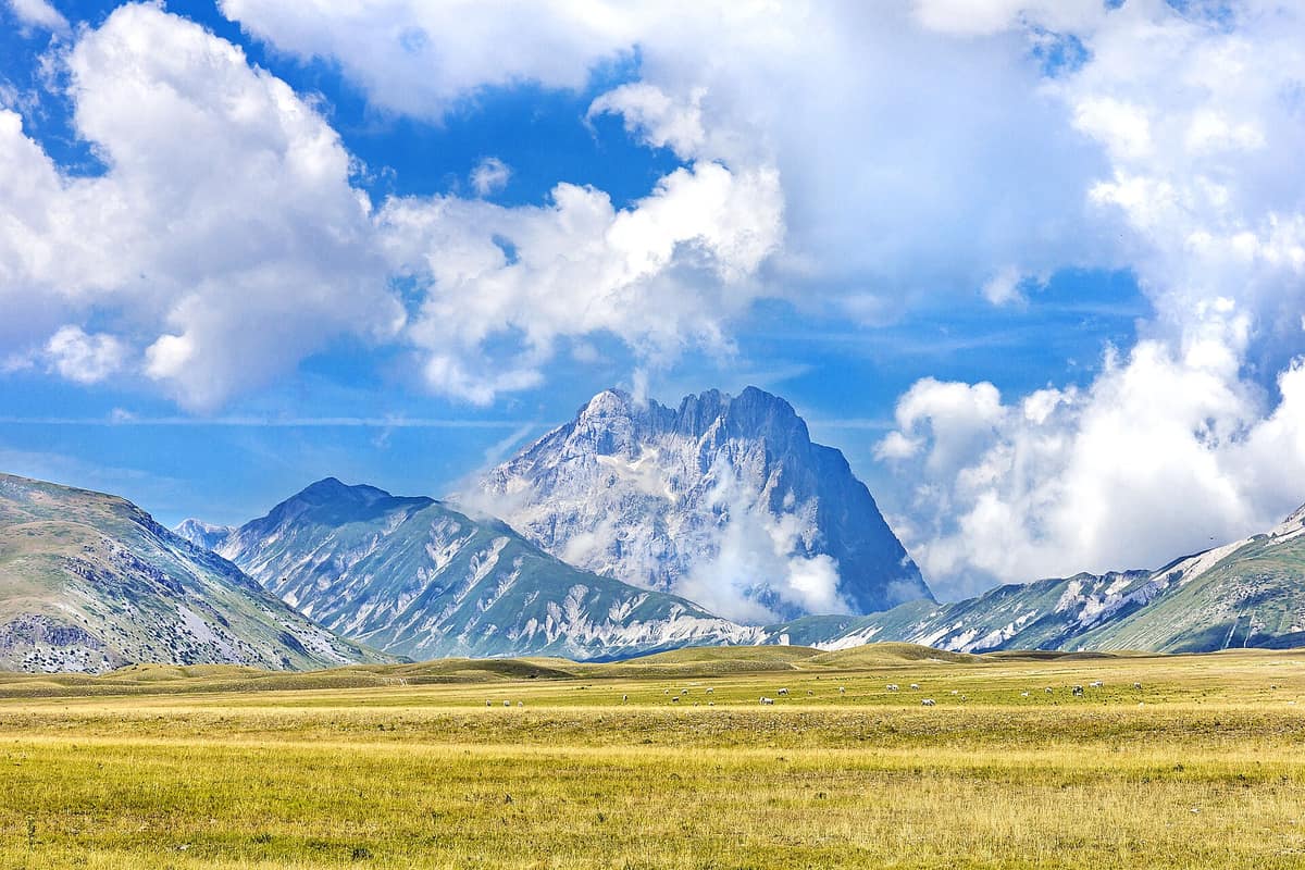
The Italian 'Little Tibet' (Campo Imperatore) crowned by Corno Grande (2.912 m, the highest peak in the Apennines) and the Calderone glacier.
There once was a true glacier in the Apennines, and its vestige lingers still. The Calderone glacier, nestled on the northern face of Corno Grande, was the only Apennine glacier and the southernmost in Italy; today it has nearly vanished, and since 2019 its remaining ice has been classified as a glacieret. That retreating ice embodies the Gran Sasso and Monti della Laga National Park: some 141.341 hectares of rugged mountains across Abruzzo, Lazio, and Marche, flanked by the sheer limestone ridge of the Gran Sasso d'Italia on one side and the verdant forests of the Monti della Laga on the other.
What makes it unique
Within a single range coexist the southernmost ice in the Apennines, a yellow pheasant's eye finding its sole Italian station here, and the Apennine chamois returned after a century-long absence.
The place
Nature
The landscape
Established in 1991, the park is the third-largest protected area in Italy. It unites the limestone massif of the Gran Sasso d'Italia with the sandstone chain of the Monti della Laga further north, structured into twelve districts, including Campo Imperatore in the upper Aterno valley and the Valle delle Grandi Abbazie, named after historic monastic abbeys in the Teramo sector of the Vomano valley.
The high alpine zone features glaciated cirques and extensive scree fans. Campo Imperatore and Campo Pericoli are vast upland plateaus of glacial origin: Campo Pericoli lies above 2.100 m. The Calderone glacier originated during the major Quaternary glaciations and reached its historical maximum extent during the Little Ice Age between 1550 and 1850.
The two massifs present striking geological contrasts. The Gran Sasso, especially on its Aquila flank, consists largely of sweeping pastures: to the southeast, forests are confined to lower elevations of black pine and oak, yielding above to open grasslands. On the northern Teramo slope, vast beechwoods dominate, particularly around Pietracamela. In contrast, the Monti della Laga are clad in unbroken forest cover: between 1000 and 1800 m stretch dense beech forests enriched with yew and holly, while ravines shelter maples, limes, ashes, and elms; pockets of silver fir and birch persist, yielding higher up to extensive bilberry heaths evoking a boreal atmosphere.
Wildlife and seasons
In spring, the slopes of the Gran Sasso reveal the golden bloom of Adonis volgensis, a plant long thought extinct that survives here at its only Italian station. At high elevations endure glacial relict endemics including Magellensis violet, Matilde's androsace, curved pheasant's eye, and Apennine edelweiss; Aquila sea lavender and Aquila milkvetch are exclusive to lower screes. The Monti della Laga harbour rare orchids, including the leafless ghost orchid.
The Apennine Pyrenean chamois disappeared from the Gran Sasso in the late nineteenth century due to hunting and was restored through reintroduction between 1992 and 1999. Hikes across Campo Pericoli offer opportunities to observe these agile ungulates. Red deer were reintroduced in 2004, the Apennine grey wolf has rebuilt stable packs, and wandering Marsican brown bear occasionally appear. Other resident mammals include red fox, wild boar, pine marten, European wildcat, European badger, stone marten, European polecat, and crested porcupine; the European snow vole thrives as an ice-age relict on high peaks.
Notable raptors include the golden eagle, northern goshawk, peregrine falcon, lanner falcon, common kestrel, merlin, and Eurasian eagle-owl. High pastures host the Apennines' largest breeding populations of white-winged snowfinch, water pipit, meadow pipit, and alpine accentor, alongside rock partridge, rufous-tailed rock thrush, and choughs. Highland screes provide ideal habitat for the endangered Orsini's viper, hosting its largest population in Italy. Amphibian endemics include the spectacled salamander and Italian cave salamander.
Species
With a page in the atlas
Being mentioned in a source doesn't guarantee sightings: check with the people who manage the area.
Memory and protection
History and conservation
Rarely can an entire conservation story be told through a single species. Here, the chamois vanished at the end of the nineteenth century and its return marks the park's crowning triumph. In contrast, the vanishing glacier represents a slow-motion loss driven by climate change.
Conservation organisations
Before you set off
Visiting
How to visit
The park maintains visitor centres and thematic museums across its villages: the Apennine Chamois Museum in Farindola, the Flower Museum in Barisciano, the Tirino River Visitor Centre in Bussi sul Tirino, the Terre della Baronia Centre in Santo Stefano di Sessanio, and the Two Parks Visitor Centre in Arquata del Tronto.
For hiking, a stage of the Sentiero Italia (CAI stage 202) leads from Santo Stefano di Sessanio to Rifugio Duca degli Abruzzi: 18,6 kilometres with 1236 metres of ascent, finishing beneath the highest peak of the Apennines. Another descent connects the refuge to Pietracamela over 12,7 kilometres. A guided loop of about ten kilometres crosses Campo Pericoli to reach Rifugio Duca degli Abruzzi from Rifugio Garibaldi, built in 1886 and celebrated as the oldest alpine hut in Italy. Other prominent mountain huts include Rifugio Franchetti in Pietracamela, Fonte Vetica, and Racollo.
Before you go
Many routes ascend beyond 2.000 m; check trail accessibility and weather forecasts with park authorities before venturing into the high mountains.
Check access, rules and visiting conditions in the official information from the managing body before you set off.
Location
Where it is and how far it reaches
Boundary of Parco nazionale del Gran Sasso e Monti della Laga · IUCN II · © EEA, CDDA (CC-BY) The coordinate is estimated; it isn't a verified access point.
Transparency
Sources
The research data with its sources, and the official links for this place, are in the Spanish version of this page. See the Spanish version
Around it
The Parco Nazionale dei Monti Sibillini directly adjoins the park, and Parco Nazionale della Majella lies about 3 km away. Twenty-four kilometres away sits Riserva Naturale Guidata Gole del Sagittario, twenty-six kilometres away Gole di Celano - Canyon delle Gole di Celano-Aielli, and twenty-seven kilometres away Parco Nazionale d'Abruzzo, Lazio e Molise, from which the chamois reintroduced here originally came.
What else to explore nearby
Approximate straight-line distance between the edges of each area. It doesn't indicate access, routes or driving times.
- Monti Sibillini National Park
Marche / Umbria (Visso / Norcia / Castelluccio di Norcia)
Borders this area
The legendary Apennine range of Monte Vettore (2.476 m), the Infernaccio Gorge, and the highland plateaus of Castelluccio.
JFMAMJJASONDMay – October · Crowding moderate
- Majella National Park
Abruzzo (Sulmona / Chieti / Pescara)
About 3 km away
The 'Mother Mountain' of Abruzzo (Monte Amaro 2.793 m), a UNESCO Global Geopark of colossal karst canyons, wild plateaus, and hanging rock hermitages.
JFMAMJJASONDMay – October · Crowding low
- Sagittario Gorge Nature Reserve
Abruzzo (Anversa degli Abruzzi / Scanno)
About 24 km away
An awe-inspiring karst canyon carved by the Sagittario River between vertical limestone cliffs hundreds of metres high.
JFMAMJJASONDMay – October · Crowding very low
- Abruzzo, Lazio and Molise National Park
Abruzzo, Lazio and Molise regions (L'Aquila, Frosinone and Isernia provinces)
About 27 km away
Sanctuary of the Marsican brown bear and Apennine wolf in primeval beechwoods and high alpine valleys of central Italy.
JFMAMJJASONDMay – June · October · Crowding moderate
If you like this place, elsewhere in Europe
Distant places with uncommon wildlife and habitats in common. The most widespread species don't count. Sharing species doesn't imply a corridor or guaranteed presence.
- Ordesa y Monte Perdido National Park
Aragon (Huesca / Torla / Broto / Fanlo / Bielsa / Escalona)
In common: Pyrenean chamois · Golden eagle — high mountain, karst and caves, glacial landscape, old-growth forest
The 'Grand Canyon of Europe', UNESCO World Heritage Pyrénées-Mont Perdu, crowned by Monte Perdido (3,355 m) with four grand canyons: Ordesa, Añisclo, Escuaín, and Pineta.
JFMAMJJASONDMay – October · Crowding moderate
- Picos de Europa National Park
Asturias / Cantabria / León (Cangas de Onís / Arenas de Cabrales / Potes / Posada de Valdeón)
In common: Pyrenean chamois · Grey wolf — high mountain, karst and caves, glacial landscape, old-growth forest
Spain's first National Park (1918), three alpine limestone massifs rising to 2,600 m just 15 km from the Cantabrian Sea.
JFMAMJJASONDJune – October · Crowding moderate
- Pyrénées National Park
Occitanie / Nouvelle-Aquitaine (Hautes-Pyrénées / Pyrénées-Atlantiques)
In common: Pyrenean chamois · Golden eagle — high mountain, glacial landscape, old-growth forest
The French slope of the central Pyrenees, twin to Ordesa: glacial cirques, bearded vultures, isards, and Pyrenean desmans.
JFMAMJJASONDJune – September · Crowding moderate
Entry #528 of the original atlas.