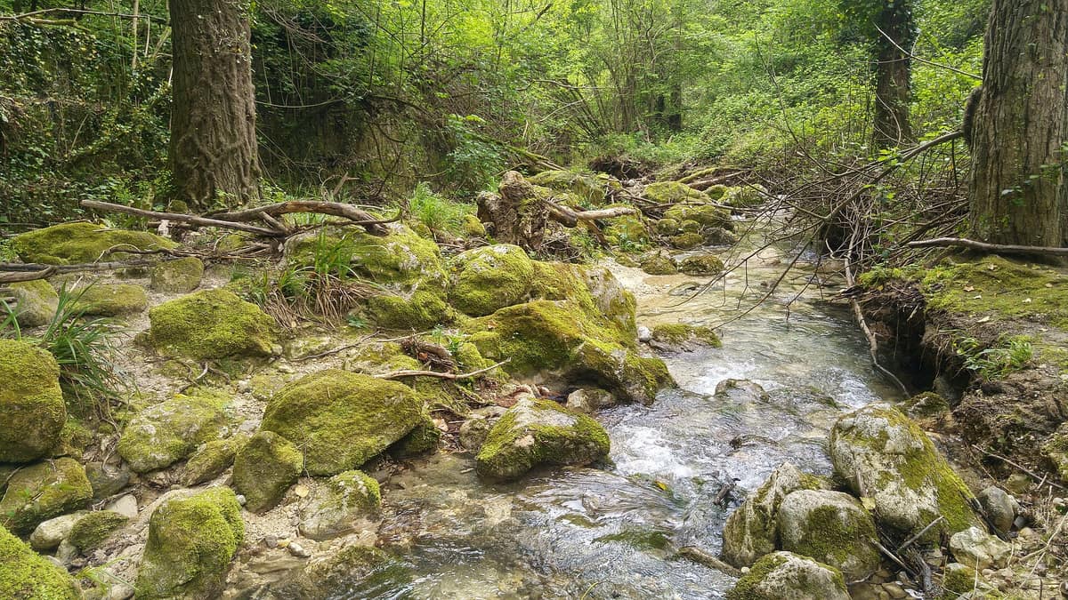
Majella National Park
Parco Nazionale della Majella
Abruzzo (Sulmona / Chieti / Pescara) · Italy
Photo: Diego.vala · CC BY-SA 4.0 · Wikimedia Commons
The 'Mother Mountain' of Abruzzo (Monte Amaro 2.793 m), a UNESCO Global Geopark of colossal karst canyons, wild plateaus, and hanging rock hermitages.
Abruzzese people call it the Mother Mountain, and gazing upon it from Campo di Giove immediately reveals why: an imposing mass of limestone soaring to 2.793 metres at Monte Amaro. Majella National Park embraces this immense massif and the neighbouring Morrone range, blending vast old-growth beechwoods, limestone canyons, karst highlands, cliff-hanging hermitages, and extraordinary wildlife into a single sanctuary.
What makes it unique
A mountain massif where you walk through prime Marsican brown bear habitat while discovering 95 geosites telling the story of the Apennines' geological birth.
The place
Nature
The landscape
The Majella and Morrone are massive Mesozoic and Cenozoic limestone and dolomite massifs. During ice ages, glaciers smoothed their summits, leaving gentle undulating plateaus, among which opens the wild Vallone di Femmina Morta above 2.500 metres. The outer flanks, especially to the east and northwest, drop through long, rugged, and canyon-like valleys.
The Orta River carves a deep chasm between the Majella and Morrone, slicing a true canyon between Bolognano and San Valentino. To the south, at roughly 1.250 metres, spread the extensive karst basins known as the «altipiani maggiori d'Abruzzo» or «quarti»: Barone, Grande, Molino, and Santa Chiara. This geology is renowned among Earth scientists because the Majella offers a rare, complete cross-section of a fossil carbonate platform margin. For this reason, the park joined the UNESCO Global Geoparks Network in 2021, featuring 95 registered geosites.
Wildlife and seasons
Beechwoods dominate: European beech (Fagus sylvatica), growing pure or mixed with silver fir, blankets much of the park alongside downy oak and Turkey oak groves. Over 2.100 plant species have been documented—nearly a third of the entire Italian flora—including localized endemics such as the Majella cornflower, blooming in rocky pastures up to 1.800 metres.
Among wildlife, the wolf serves as the park's emblem and appears on its official crest: around eleven packs range across the massif. Marsican brown bear numbers are smaller: the 2019 monitoring confirmed at least 15 individuals, six of them permanent residents. The Apennine chamois, reintroduced to these slopes, now forms its largest population here, exceeding 1.500 animals in 2021. Red deer and roe deer returned in the nineteen-eighties. The skies shelter northern goshawk, rock partridge, peregrine falcon, and choughs, while high alpine screes harbour the rare Orsinis viper.
For closer wildlife encounters, visitor areas operate dedicated facilities: at Lama dei Peligni a semi-wild enclosure shelters Apennine chamois; Caramanico Terme maintains an otter centre where otters are often observed in the late afternoon; while the wolf enclosure at Pretoro houses shy wolves in extensive woodland.
Species
With a page in the atlas
Being mentioned in a source doesn't guarantee sightings: check with the people who manage the area.
Memory and protection
History and conservation
On Monte Morrone, Benedictine monks planted silver firs around 400 years ago in Fossa di Pentima, the oldest recorded reforestation in the region. In the Bosco di Sant'Antonio, shepherds historically pollarded beeches to fodder cattle, sculpting the remarkable candelabra beeches characteristic of this ancient wood. Spiritual roots run equally deep: the Abbey of San Liberatore a Maiella dates from the eleventh century, while San Martino in Valle was abandoned in 1818 following a catastrophic flood.
The national park was instituted by presidential decree on 5 June 1995, with headquarters in Guardiagrele, encompassing seven state nature reserves.
Rewilding projects
Before you set off
Visiting
How to visit
The trail network spans more than 1.200 kilometres, offering family nature trails, historical walks, and high-altitude treks. Four themed long-distance routes structure the park:
- The Sentiero del Parco traverses from Popoli to Palena station, summiting the highest peaks from Monte Amaro to Monte Porrara. - The Sentiero dello Spirito links Sulmona to Serramonacesca, visiting cliff-hanging hermitages, abbeys, and rupestrian shrines, notably those founded by Pope Celestine V. - The Sentiero della Libertà from Sulmona to Palena traces the historic escape route used by thousands of Allied prisoners of war after the armistice. - The Sentiero delle Capanne in pietra connects Lettomanoppello, Abbateggio, Roccamorice, Caramanico, and Serramonacesca, highlighting traditional dry-stone pastoral huts (tholos).
Main road gateways are Sulmona to the west, Pescocostanzo to the south, Guardiagrele to the east, and Lettomanoppello to the north. Information centres offer guided activities: Fara San Martino reconstructs a pastoral cave, Lama dei Peligni features chamois and geomorphology dioramas, Caramanico Terme combines natural history with archaeology, and the Palena bear museum occupies an ancient convent. The newest visitor centre is at Badia di Sulmona. Botanical gardens at Sant'Eufemia a Maiella and Lama dei Peligni help identify local alpine flora.
Before you go
Check trail conditions and municipal closure ordinances before your excursion. The Pretoro wolf enclosure is accessible only on guided tours.
Check access, rules and visiting conditions in the official information from the managing body before you set off.
Location
Where it is and how far it reaches
Boundary of P N DELLA MAIELLA · IUCN II · © EEA, CDDA (CC-BY) The coordinate is estimated; it isn't a verified access point.
Transparency
Sources
The research data with its sources, and the official links for this place, are in the Spanish version of this page. See the Spanish version
Around it
Just 3 km away lies the Gran Sasso and Monti della Laga National Park, and 12 km away the Abruzzo, Lazio and Molise National Park. At 15 km is the Gole del Sagittario Nature Reserve. Further afield, it shares chamois, wolf, and bear populations with the Picos de Europa and Somiedo.
What else to explore nearby
Approximate straight-line distance between the edges of each area. It doesn't indicate access, routes or driving times.
- Gran Sasso and Monti della Laga National Park
Abruzzo / Lazio / Marche (L'Aquila / Teramo / Rieti)
About 3 km away
The Italian 'Little Tibet' (Campo Imperatore) crowned by Corno Grande (2.912 m, the highest peak in the Apennines) and the Calderone glacier.
JFMAMJJASONDMay – October · Crowding moderate
- Abruzzo, Lazio and Molise National Park
Abruzzo, Lazio and Molise regions (L'Aquila, Frosinone and Isernia provinces)
About 12 km away
Sanctuary of the Marsican brown bear and Apennine wolf in primeval beechwoods and high alpine valleys of central Italy.
JFMAMJJASONDMay – June · October · Crowding moderate
- Sagittario Gorge Nature Reserve
Abruzzo (Anversa degli Abruzzi / Scanno)
About 15 km away
An awe-inspiring karst canyon carved by the Sagittario River between vertical limestone cliffs hundreds of metres high.
JFMAMJJASONDMay – October · Crowding very low
If you like this place, elsewhere in Europe
Distant places with uncommon wildlife and habitats in common. The most widespread species don't count. Sharing species doesn't imply a corridor or guaranteed presence.
- Picos de Europa National Park
Asturias / Cantabria / León (Cangas de Onís / Arenas de Cabrales / Potes / Posada de Valdeón)
In common: Pyrenean chamois · Brown bear · Grey wolf — high mountain, karst and caves, gorge and canyon, old-growth forest
Spain's first National Park (1918), three alpine limestone massifs rising to 2,600 m just 15 km from the Cantabrian Sea.
JFMAMJJASONDJune – October · Crowding moderate
- Monti Sibillini National Park
Marche / Umbria (Visso / Norcia / Castelluccio di Norcia)
In common: Pyrenean chamois · Brown bear · Grey wolf — high mountain, karst and caves, gorge and canyon
The legendary Apennine range of Monte Vettore (2.476 m), the Infernaccio Gorge, and the highland plateaus of Castelluccio.
JFMAMJJASONDMay – October · Crowding moderate
- Aigüestortes and Lake Saint Maurici National Park
Catalonia (Lleida)
In common: Pyrenean chamois · Fagus sylvatica — high mountain, old-growth forest
The only National Park in Catalonia, a glacial circus wonderland harboring over 200 tarns (estanys) beneath the iconic twin summits of Els Encantats.
JFMAMJJASONDJune – October · Crowding moderate
- Călimani National Park - Volcanic Forest Massif
Suceava, Mureș, Bistrița-Năsăud, and Harghita Counties
In common: Fagus sylvatica · Brown bear · Grey wolf — high mountain, old-growth forest
The largest extinct volcanic crater in Europe (10 km in diameter) covered with high-mountain fir and spruce forests.
JFMAMJJASONDJune – October · Crowding very low
Entry #527 of the original atlas.